Property Listing: Status: Active (Listed on: 04/21/2024)
Perfect for Target Shooting
Listing ID:
18813
Price:
$17,950
10.00 Acres +/-
Owner Financing Available


General Location:
Adelanto, San Bernardino County, California
Address:
EM 4800
City, State Zip:
Adelanto, CA 92301
County:
San Bernardino County
MLS #:
0462-043-02
Listing ID:
18813
Description:
ONLY $400 PER MONTH - 10.0 ACRES (#213) NORTHWEST OF ADELANTO, SAN BERNARDINO COUNTY, $18,950 SELLER FINANCING: $1,000 DOWN PAYMENT, $400 PER MONTH, 60 MONTHS, 10% DISCOUNT FOR CASH ($17,950)
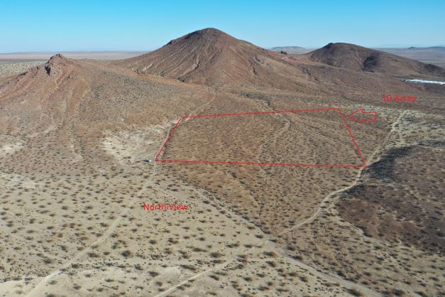
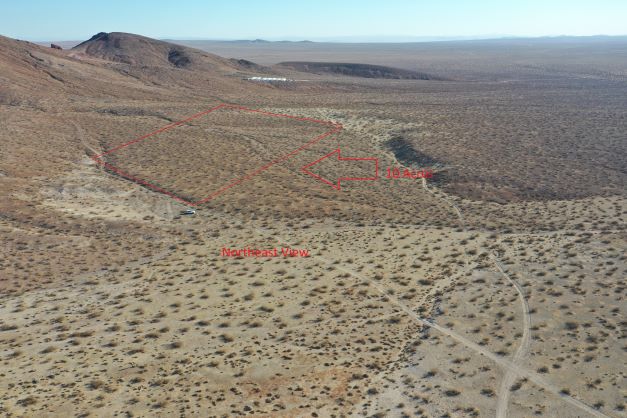
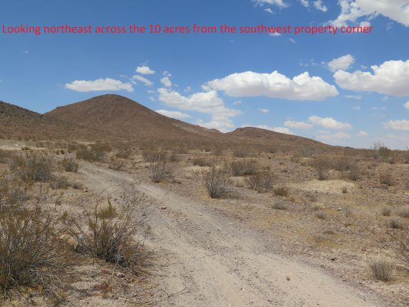
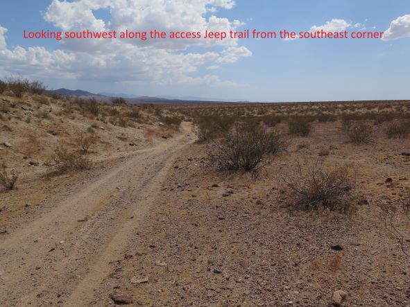
PERFECT FOR TARGET SHOOTING OR RIDING YOUR OHV. This impressive 10.0 acres northwest of Adelanto is perfect for TARGET SHOOTING, RV and OHV use. Red Buttes Mountain is north of the property making a good backstop for target shooting. Or live off the grid on your own land. This 10 acres is just 2.6 miles west of Highway 395. This property has good Jeep trail access (see Google Earth aerials). The surrounding area has miles of roads and Jeep trails to explore. There is 640+ acres of BLM land 660 feet to the west for recreation use. You are close enough to Adelanto for easy access to food and gas, yet far enough away from civilization to enjoy the quiet solitude of the desert.
This 10.0 acre parcel is northwest of the scenic Southern California high desert community of Adelanto. The property is an hour drive from the Riverside-San Bernardino area. You take I-15 north through the Cajon Pass to Highway 395. You travel north on Highway 395 seven miles north of Shadow Mountain Road to BLM Open Route EM4800. You then travel 3 miles southwest on EM4800 to a Jeep trail that takes you to the 10 acres. You take the Jeep 0.75 miles north then east to the southeast property corner.
The parcel has RC (resource conservation) zoning that permits one home or camping use. There is no electric or developed source of water to the parcel. The San Bernardino County Assessor parcel number is 0462-043-02. The parcel measures 660 feet by 660 feet containing 10.0 acres. The buyer should contact San Bernardino County to investigate all zoning and development issues for the parcel.
The 5 Google Earth aerial photographs show the access route from Highway 395 via EM4800. The GPS coordinates for the southeast property corner are 34.812224, -117.538999. Just copy and paste these coordinates into Google Maps using your web browser and/or put these coordinates in the Google Maps App on your smart phone and navigate to the property. You can zoom in or out using map view or satellite view to see the surrounding area. Or, see my listing of this 10 acres with a drone video on LandFlip.com at www.landflip.com/land/336461.
SELLER FINANCING OPTION 1: You can purchase this parcel for $19,950 with a $1,000 cash down payment with the balance of $18,950 financed at 7% interest for 60 months. Your monthly payment will be $375.00 plus $25.00 for property taxes for a total payment of $400.00. I will email you a Land Sale Contract whereby you will agree to pay in installments of $400.00 per month. You will receive a deed to the property upon full payment of the purchase price.
SELLER FINANCING OPTION 2: You can purchase this parcel for $19,950 with a $6,000 cash down payment with the balance of $13,950 financed at 7% interest for 60 months. Your monthly payment will be $276.23. The buyer and seller will each pay 50% of escrow fees and closing costs, The seller will pay title insurance. We can open escrow as soon as I accept your offer. You will receive a deed to the property upon close of escrow.
CASH SALE: You can purchase this parcel for $17,950 cash which is a 10% discount from the seller financed price of $19,950. The buyer and seller will each pay 50% of escrow fees and closing costs. The seller will pay for title insurance. We can open escrow as soon as I accept your offer. You will receive a deed to the property upon close of escrow.
This property is sold “as is” with no warranties given by the seller. The buyer should do their own investigation to determine if this property is suitable for their particular usage or purpose. The sale is final with no refunds for any reason.
https://www.youtube.com/embed/rx3rPJMnRpg
Directions:
The property is an hour drive from the Riverside-San Bernardino area. You take I-15 north through the Cajon Pass to Highway 395. You travel north on Highway 395 seven miles north of Shadow Mountain Road to BLM Open Route EM4800. You then travel 3 miles southwest on EM4800 to a Jeep trail that takes you to the 10 acres. You take the Jeep 0.75 miles north then east to the southeast property corner.
Map:
34.8122, -117.539(Click the marker to open in Google Maps.)